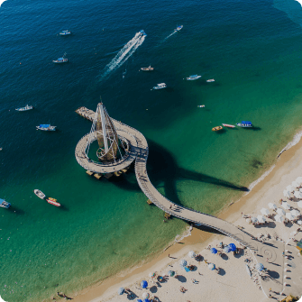
South Zone beach
South of downtown Vallarta and the Romantic zone the highway going south runs along the edge of the sea and the lush green jungle hills that drop into the bay. This area has been developed mainly as a residential area and offers some very beautiful resorts, many with their “own” beaches and coves.
Check out the Zone map if you don’t know the general layout of the city, it’s not hard at all as it all lies along the edge of Banderas Bay in a north-south curve.
There are many nice beaches, Los Arcos, the Zoo, Vallarta Botanical Gardens and the isolated South-Pacific-like beaches and towns south of Boca de Tomatlán that can only be reached by water taxi.
Main features found on this map:
- Los Arcos Marine Reserve – read more
- Mismaloya Beach – read more
- The Set of the Night of the Iguana – read more
- Vallarta Zoo – read more
- Bungee Jumping – read more
- Boca de Tomatlán – read more
- Las Ánimas – read more
- Quimixto – read more
- Las Caletas – read more
- Majahuitas – read more
- Yelapa – read more
- Vallarta Botanical Gardens – read more
FAQ

Book tours & support us
- Best prices
- 100% Local Support
- 2 decades+ of experience in Puerto Vallarta

Puerto Vallarta news, tips & content
- New info every two weeks
- Free content, news, videos
- Unsubscribe at any time

Contact us via WhatsApp
- Talk with our reservations expert
- Real local and human support
- Book tours, hotels, transfers, and more.
Share this article, choose your favorite option!